
Precision Aerial Data Acquisition & Imaging in Orlando
Strategic Aerial Insights for Florida
For any aerial data acquisition requirement in Florida, Orlando Helicopter Charters delivers comprehensive solutions leveraging the unique low-altitude and hover capabilities of helicopters. This includes precision operations for magnetometer and electromagnetic surveys, LiDAR data collection, and advanced GIS mapping. We also specialize in high-definition aerial cinematography and photography services, offering technical versatility from custom camera modifications for handheld projects to providing specialized gyro-stabilized platforms. Our extensive options are designed to capture Florida from an unparalleled aerial perspective, ensuring exceptional data quality and visual results.

Aerial
Surveys
LiDAR, GIS Maps, FLIR, HD Video & More
Orlando Helicopter Charters provides comprehensive support for critical infrastructure oversight, encompassing precise pipeline integrity surveys, expansive right-of-way inspections, and detailed transmission line patrols across Florida. We ensure the deployment of suitable rotorcraft, equipped with the necessary advanced sensor packages, to facilitate accurate data collection and rigorous asset management for your projects.
High Tech Results
The Top Pilots in Florida, Today's Technology... Maximum Results.
Call 407-720-4490 Now!
Orlando Helicopter Charters provides the tools needed to complete your land surveys, utilizing the right equipment to provide the aerial photos that are often needed.
Effective aerial data acquisition streamlines critical right-of-way and site inspections, facilitates precise topographical data collection, and enables high-resolution imagery for commercial projects across Florida. Helicopter-based surveys offer unparalleled versatility for inspecting pipelines for anomalies, assessing transmission line integrity, and documenting property conditions. Orlando Helicopter Charters specializes in developing customized photographic and remote sensing operations, engineered to maximize both technical efficiency and financial viability, thereby ensuring superior project outcomes.
The operational parameters of a helicopter, allowing for significantly lower and slower flight profiles compared to fixed-wing aircraft, make it the optimal platform for detailed aerial surveying. While fixed-wing operations are typically restricted by FAA regulations to altitudes above 1,000 feet, helicopters can navigate much closer to the ground. This capability is critical for inspecting challenging or hazardous zones, providing engineers and project managers with a unique perspective unattainable by conventional aerial platforms.
There is no better way to conduct your visual survey, animal population counts, soil drainage analysis, ROW inspections, pipeline and transmission line inspections, and geographical surveys.

LiDAR Imaging
Light Detection and Ranging, or LiDAR, is a remote sensing method used to examine and measure Florida topography as well as objects, like vegetation, upon it.

Infrared Imaging
Thermographic IR cameras are used to detect radiation in the long-infrared range of the electromagnetic spectrum and produce images of that radiation, called thermograms.

HD Video Gimbal Capture
Modern HD and 4K cameras can be mounted to helicopters, using the proper STCs, with a gimbal to stabilize photos & videos for detailed results.

Advanced Aerial Cinematography & Professional Imaging
For expert camera work in the Orlando Sky
Get a Fast, free QuoteOrlando Aerial Cinematography
Orlando Helicopter Charters provides access to comprehensive resources for professional-grade aerial cinematography and photography across Florida. Our network facilitates custom shoots utilizing cutting-edge gyro-stabilized camera mounts, including Tyler Mounts, Wesscam, Cineflex, Pictorvision, and SpaceCam, paired with advanced camera systems such as Cineflex HD, RED Epic, Arri Alexa, and even specialized 3D and experimental cameras. We support all facets of production goals, from intricate air-to-air sequences to precise ground-to-air compositions, ensuring seamless integration with your aerial Director of Photography and production team. Specializing in both still and motion photography, Orlando Helicopter Charters provisions rotorcraft for diverse media operations in Florida, including feature films, television productions, documentaries, promotional videos, commercials, aerial props, and comprehensive coverage of major events, ensuring exceptional visual results.
Call Us Today at 407-720-4490 for a Free Quote
Contact Us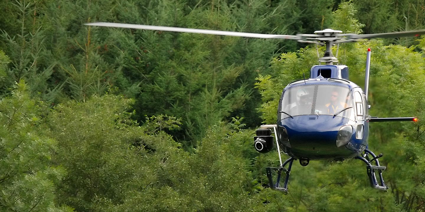
Aerial Photos
Hand-held or Mounted OpTions in Orlando
We will help you get the right equipment for your aerial photography project! Call 407-720-4490 today to get a fast, free quote.
The Most Options for Photography
Transform your artistic and commercial visions into high-definition aerial imagery across Florida’s spectacular landscapes. Orlando Helicopter Charters offers specialized aerial photography charters engineered to capture precise perspectives, translating your conceptual designs into tangible visual assets. We provide cost-effective solutions for photographic missions throughout the state, ensuring exceptional clarity. Many rotorcraft are adaptable for handheld camera work via door removal, and we also provide access to advanced gyro-stabilized camera mounts for projects demanding superior stability and precision.
Superior Service
Every one of our customers gets a dedicated helicopter expert to assist with flight plans, tech loadouts, production logistics, project schedules, and other demands.
Over 500 Aircraft
Our network of direct air partners extends well beyond Orlando, Florida. This allows us to offer a wide range of solutions for even the most sophisticated projects.
The Best Equipment
From high-tech sensors like LiDAR, FLIR, and GIS to HD cameras and movie production gimbals, we're here to make your job as easy as possible.